Last Updated on 12th July 2020 1:18 PM by AfriWX
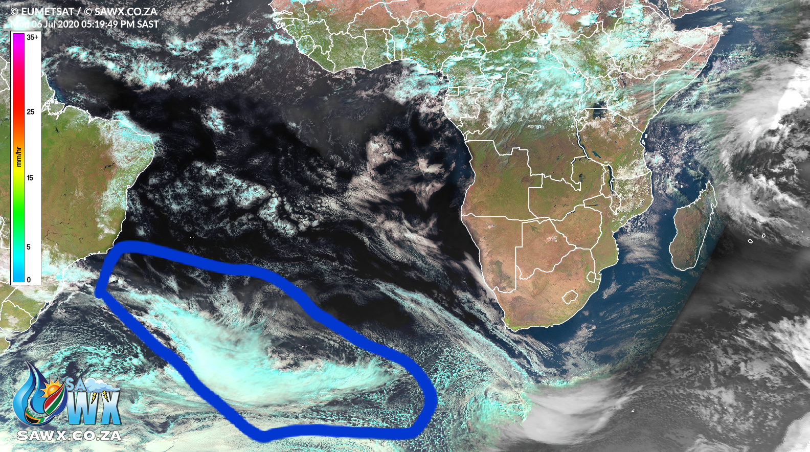
The entire weather community in South Africa has eyes on the mammoth #coldfront developing in the South Atlantic (circled in blue) this system, arriving Thursday, promises to bring heavy rains and widespread #snow to a great deal of SA and even #namibia if the system stays on track. https://t.co/zqDIkga0QZ
We will keep you updated but it sure does look like one of the most eventful winter weekend for Southern Africa in decades.
Our forecasts show this system is not only staying on course but is also strengthening substantially and should make for one of the most eventful winter weekend in Southern Africa in many years. Keep a close watch for warnings and alerts.om Twitter, Facebook, TV and Radio in this regard.
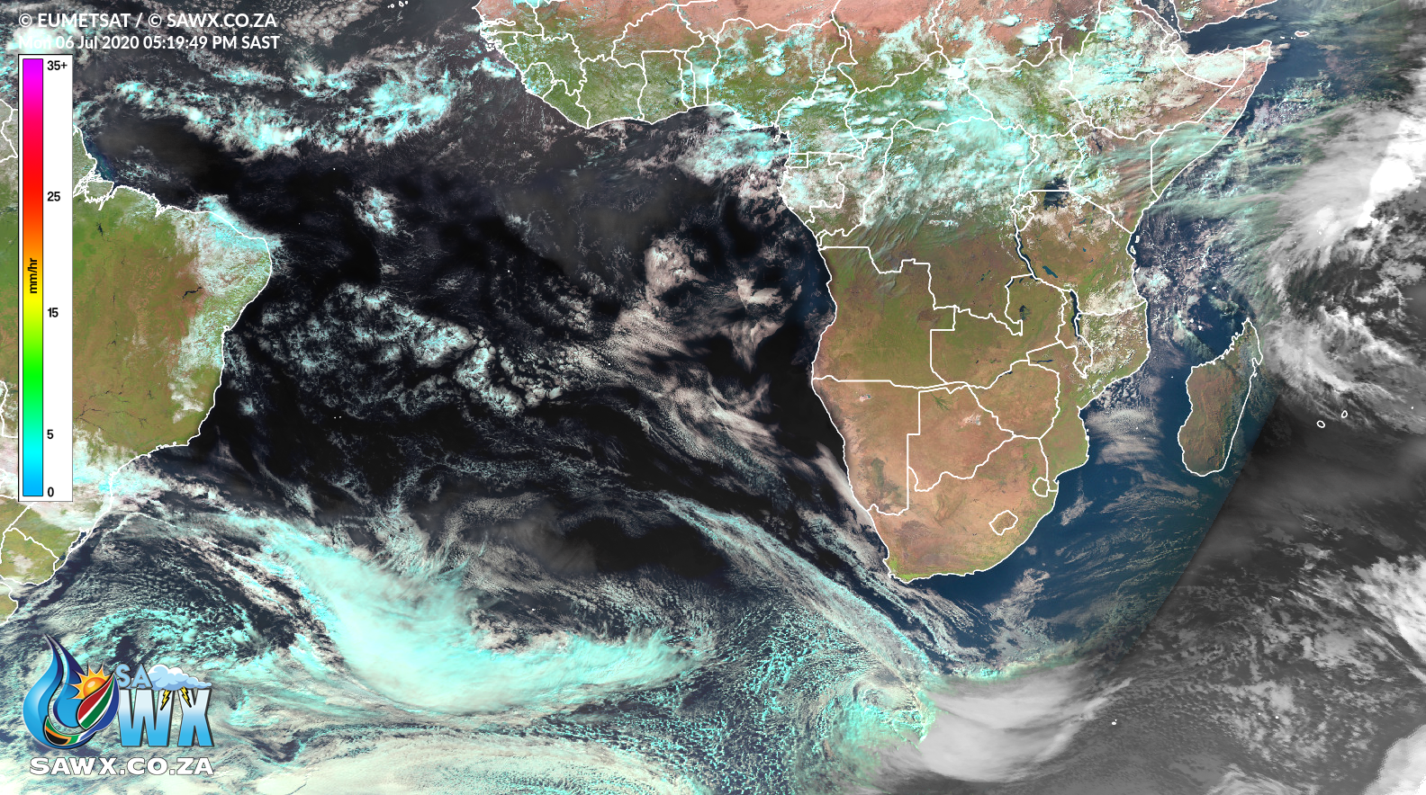
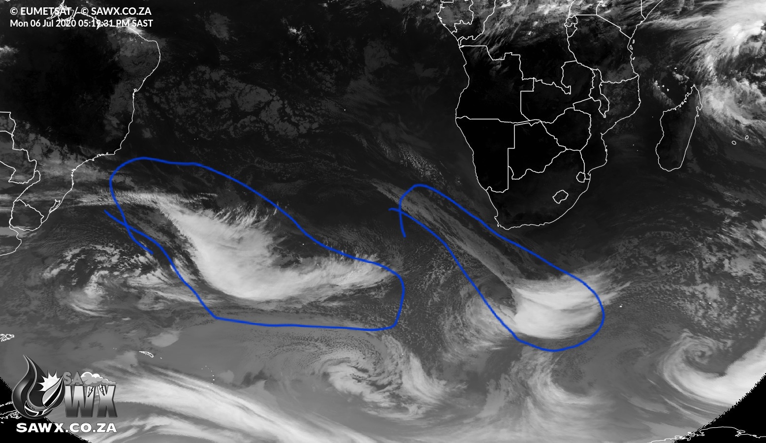
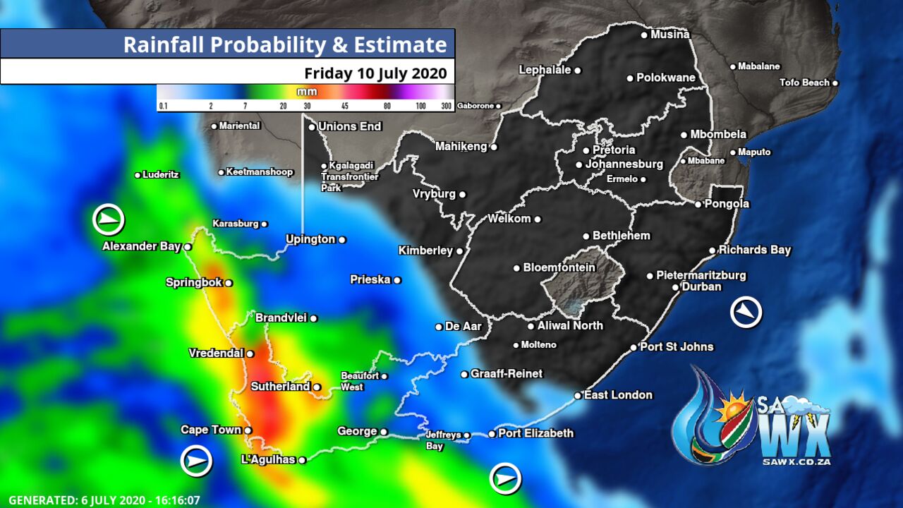
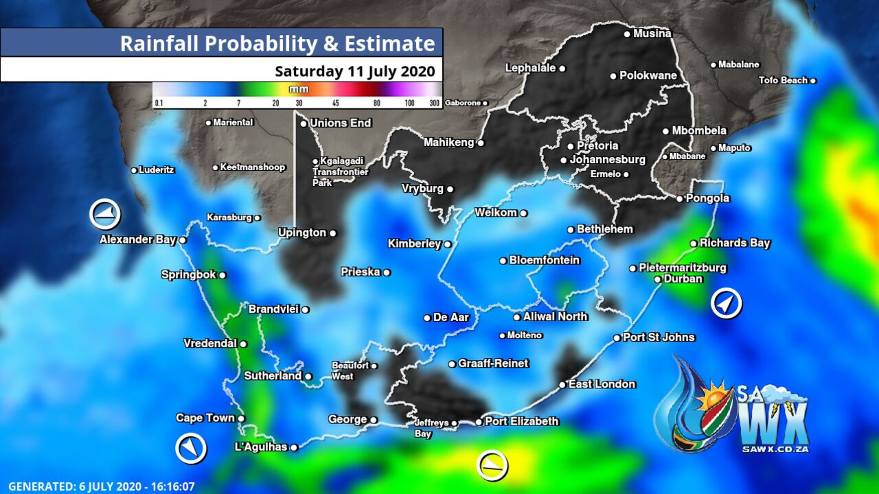
Here is the latest synopsis on this big event not seen in many years from Mike Berridge of Weather Today Southern Africa
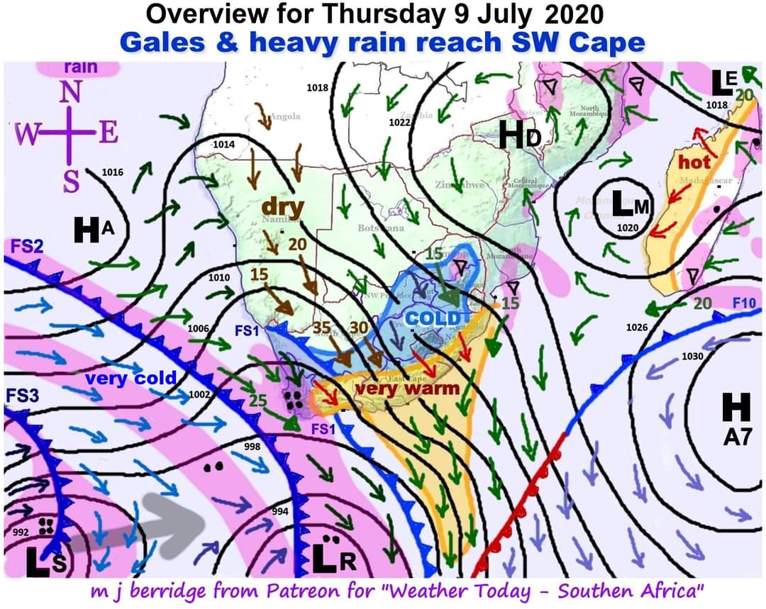
Here are the big ones that many people have been dreaming about for ages. Far out in the Atlantic Ocean, a series of mid-latitude cyclones wondered rather further north than in recent years. Hence the approach of the systems shown here, which I will describe “step-by-step”:-
Extending from the mid-latitude cyclone “LR” at the bottom of the diagram we see a broad low pressure trough extending way up the west coast as far as Angola in the north. The wind circulation around low pressure systems is CLOCKWISE, so we see the strengthening of the overland north-west winds. In the central Cape highlands these winds will attain gale force as shown at the tails of the wind arrows. Gusts could reach 100km/hr (>50 knots).
When these winds start moving downwards towards the altitude of the sea, the southern and south-eastern regions will become very warm due to adiabatic heating as the winds blow downwards. This process is shaded orange with red wind arrows.
The diagram represents 2 p.m. when the front marked “FS1” has already moved into west Cape. This will accompany the onset of moderate to heavy rain over the far south-west Cape. The seaward end of this front is detached by the effect of the adiabatic berg winds. The front is marked “FS1” which stands for “frontal stage 1”
“FS2” will reach the Cape after sunset. It will join up with “FS1” to produce a large rain area over the south-west and west Cape overnight and tomorrow (Friday) – also penetrating south-west Namibia.
Late tomorrow (Friday) “FS3” will arrive as additional back-up to the cold and heavy rain and will be discussed in tomorrow’s bulletin. The directional movement of the mid-latitude cyclone “LS” associated with this third front is shown with a broad grey arrow.
And as if this is not enough, “frontal stage 4” (not yet in view) is on it’s way and will strike on Sunday night with gales exceeding 35 knots.

Pingback: Brrrace yourselves: Mammoth cold front to bring heavy rain, widespread snow to SA | News24 – The Health News Center
Pingback: Brrrace yourselves: 'Mammoth' cold front to bring heavy rain, widespread snow to SA | News24 - News Portal
Pingback: Brrrace yourselves: 'Mammoth' cold front to bring heavy rain, widespread snow to SA - The News Portal
Pingback: Brrrace yourselves: 'Mammoth' cold front to bring heavy rain, widespread snow to SA | News24 | News Nation Global
Pingback: Brrrace yourselves: 'Mammoth' cold front to bring heavy rain, widespread snow to SA » Mr. Pintoo NEWS
Will this affect Durban, KZN? We already have very strong winds
KZN will continue to see some strong wind and there is indeed chances parts of the province will see snow.
Pingback: Brrrace yourselves: Mammoth cold front to bring heavy rain, widespread snow to SA | News24 – MySite
And limpopo, are any snow or strong winds expected?
Our latest wind maps confirm most of the country will see some strong winds but Limpopo does not seem it will be that badly affected – https://sawx.co.za/wind/
Pingback: Brrrace yourselves: ‘Mammoth’ cold front to bring heavy rain, widespread snow to SA | News24
What chance of snow on the Southern Drakensberg?
Very good indeed
How hard will it hit Bloemfontein/Thaba Nchu area? Central FS
Snow is expected across a fair amount of the Free State, VERY strong winds can be expected from Thursday into Friday.
Please keep me posted
We shall do. Stay safe and stay warm.
Pingback: Brrrace yourselves: ‘Mammoth’ cold front to bring heavy rain, widespread snow to SA | News24 – Smart2buy
will there be snow in Gauteng?
Not looking very likely but not impossible either, we have to see close to Thursday evening how the system has developed
How will this affect Johannesburg Soweto area
A very cold snap and minimal chances for snow, we will keep you updated
The weather for gauteng, what can we expect.
A very cold snap with minimal chances for snow but we are monitoring
Do you think it is safe to travel from Queenstown to Cape Town over the coming weekend in a Minibus Taxi in view of the predicted storm?
We should get advisories from the weather service today. Keep a watch for any announcements
Good evening
Possibility of snow in Pretoria?
Minimal but we shall have to see how this system continues to develop
What about Kleinmond south western cape
Almost the entire Western Cape could see some heavy rain and snow https://twitter.com/sawx_sa_weather/status/1280737396506722305?s=19
There were upwards of 50 chokka boats moored in Algoa Bay today. I have never seen that many before. Obviously they must have been instructed to shelter here from the wind.
Going to be some insane winds from this #coldfront check our wind maps out https://sawx.co.za/wind/
What about Johannesburg?
A very cold snap and minimal chances of snow but not impossible, we shall have to see how this plays out now
Will it snow in Nottingham Road in Kzn
Will it snow in Nottingham Road in KZN
Chances look pretty good for the Midlands
https://twitter.com/sawx_sa_weather/status/1280737396506722305?s=19
Please keep me informed of other weather patterns in future
Does it look like Gauteng will not feel it as badly as the rest of the country?
Wind speeds in SW
Will we see snow in Vaaloewer
What will the weather be in Kimberley, NC
Chances of snow for Kimberley and much of the Northern Cape look quite good still
How cold will hopetown in the northern cape be?
Will it be hard in Gauteng Province if yes, expected how many days?
A very cold snap for Gauteng but chances of snow are minimal
How hard will it hit Middelburg Mpumalanga
Will it be overcast or sunny skies in mpumalanga
How would this cold front affect Kathu Northern Cape any chance of rain or even snow
Hi there
I’m Dirk Kleinschmidt from Informante Radio Windhoek Namibia. Please provide me wit a name and contact no of a person that I can interview on the cold front moving into Southern Africa and how this may affect Namibia. My contact detail +264811465517.
Could flights from Durban to Cape Town on Saturday morning be affected?
Serious one,it will exacerbate covid-19 casualties in the region
When will this front be felt in the Lowveld of Mpumalanga and how?
Hello will it snow in Cape town area – in the western cape somewhere
What must we expect on Saturday in Pretoria?? Wind , snow,rain or very cold weather?
Will Mosselbay be having snow
What is the weather prediction for the South Coast?
How will this cold front affect Prt Alfred?
How hard will it hit Strand/Somerset West? I stay on Beach Road.
How will Port Elizabeth be affected regarding rain, wind, snow etc?
I imagine snow for the Hantam Moutains in Calvinia with freezing to near freezing temps?
I imagine that you we should see snow in Cape Town, this weekend?
How Does the weather look for Richards Bay this coming weekend.
Flooding in swapping likely on Thurs 9/7/2020?
Flooding in sea point likely on Thurs 9/7/2020?
How does the weather look for Richards Bay this coming weekend
How will this front effect Saint Helena Island (SAO)?
Hi, wind strength in somerset west this coming weekend?
Here’s out latest wind maps – keep a check daily at https://sawx.co.za/wind/
Gauteng will have rain tomorrow
How bad will somerset west. Cape Town experience this mammoth storm. Severe or not so severe. Is it likely that the wind will uproot trees and cause substantial damage
Somerset west can expect snow. Trees and indeed cars may be uprooted. Hold onto your hats.
How will Port Elizabeth be affected?
How will we in Pietermaritsburg be affected and for how many days will it last
Will it be safe to Travel from Middelburg Eastern cape to Cradock on Thurday morning?
Thursday should still be okay, very strong winds expected across much of the interior so travel safe and please keep a watch on warnings issued.
How bad will camping /fishing in Hopetown Bloemhof area be affected?
A very cold good morning. How about NW Botswana and Namibia borders? Will we see snow or rain?
Southern Namibia has a good chance to see some light snow, if lucky it may stretch more inland to the border with Botswana, we shall see.
Just for interest how does this weather compare with September 1957 when the rail line over majuba near volksrust was SNOWED CLOSED.
How will Port Elizabeth be affected can we expect some rain we need it badly
Possible snow in Newcastle, kzn?
How will Pietermaritzburg be affected?
Hi, What will be the effect in Nelspruit, Mpumalanga on the weekend?
Hi, What will be the effect in Nelspruit on the weekend?
Pingback: News24.com | Brrrace ustedes mismos: frente frío 'Mamut' para traer fuertes lluvias, nieve generalizada a SA | Istem Latino
which place has the lowest recorded temperature forecast